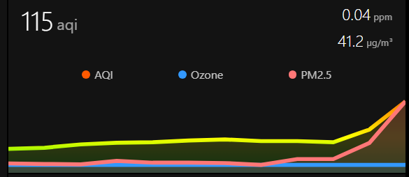
Given that the air quality is going to shit in m y area again, I figured I’d show off my air quality cards! Let me know if you have any questions. The colors for the AQI cards are from US EPA’s color set and the the PM2.5 color values are based off EPA’s PM2.5 exposure over 24 hours
 ^ These are based off the stock gauge card.
type: gauge
entity: sensor.airnow_aqi
name: AQI
unit: ' '
needle: true
min: 20
max: 500
segments:
  - from: 0
    color: '#00e400'
  - from: 51
    color: '#ffff00'
  - from: 101
    color: '#ff7e00'
  - from: 151
    color: '#ff0000'
  - from: 201
    color: '#8f3f97'
  - from: 301
    color: '#800000'
type: gauge
entity: sensor.airnow_pm2_5
name: PM2.5
needle: true
min: 0
max: 200
segments:
  - from: 0
    color: '#64a13c'
  - from: 12.6
    color: '#eac51c'
  - from: 26
    color: '#d67900'
  - from: 51
    color: '#a90737'
  - from: 151
    color: '#50051e'
 ^ This one is based off the mini-graph-card, which I really like.
type: custom:mini-graph-card
name: Air Quality
icon: mdi:air-purifier
hours_to_show: 12
points_per_hour: 1
smoothing: false
color_thresholds:
  - value: 0
    color: '#00e400'
  - value: 51
    color: '#ffff00'
  - value: 101
    color: '#ff7e00'
  - value: 151
    color: '#ff0000'
  - value: 201
    color: '#8f3f97'
  - value: 301
    color: '#800000'
entities:
  - entity: sensor.airnow_aqi
    name: AQI
  - entity: sensor.airnow_o3
    name: Ozone
    color: '#3399ff'
    show_state: true
  - entity: sensor.airnow_pm2_5
    name: PM2.5
    color: '#ff7777'
    show_state: true
    y_axis: secondary
I tend to not use the mini-graph-card as I find it not customizable enough; too much room is taken up by other things than the graph itself (legend mostly).
What are you using instead?
I’m using [https://community.home-assistant.io/t/plotly-interactive-graph-card/347746](Plotly Graph) for my solar panels. I do use some small mini-graph-cards without a legend though, but not as much as I expected to use them in the beginning.
Honestly that looks 10x better, and there’s a decent chance I’m switching tomorrow. Thanks!
Cheers for that. I’ve recently added WAQI integration to my system, and hadn’t thought that you could add more colours.
Wow, i didn’t know AirNow was a thing. Making that card now! Will be more and more helpful as time goes on unfortunately
These look good. What source of data are you using?
I forgot to mention that, but the Airnow integration has been pretty good. I was using Airvisual Cloud, but that doesn’t seem to be as accurate.
Upper Midwest? Milwaukee here, yesterday was awful.
Western NY. It’s been pretty rough, but I think the lakes help moderate it a bit


